+91 6002993949
submission@iarconsortium.org
Open Access
ISSN (Print) : 2708-5090
ISSN (Online) : 2708-5104
The article points out natural and anthropogenic factors contributing to the formation, development and alteration of agricultural landscapes in western Georgia, specifically, in the Colkheti coastal plain and the adjacent hilly foothill zone, where subtropical agriculture used to be heavily developed (tea and citrus plantations, etc.). The former state-owned tea farm zone in the borough of Laituri, Ozurgeti municipality, Guria was selected as the study location. GIS technologies were applied to digitalize the 1960 landscape map of the zone and create its new version (1:50 000) as of 2017 based on the topographical map of 1960 (1:50 000), satellite images and field observations (2010-2017).
The analysis of the Laituri 1960 and 2017 landscape showed that 66% of tea plantations have been amortized and degraded: they have gone wild and are overtaken by weeds. Due to high costs involved, only 10% of the area was cleared to cultivate hazel nuts, blue huckleberry and persimmon. 24% of tea plantations survive to varying degrees and are currently harvested.
Georgia is a country with favourable conditions for growing distinct subtropical agricultural species (tea, citrus, feijoa, kiwi and etc.). The subtropical agriculture is mainly developed on approximately 400 000 ha area of the Black Sea humid subtropical zone in West Georgia. In formation of the agicultural landscapes in this territory many natural and anthropogenic factors take place. The role of the latter is significant in the formation of the humid subtropical landscapes of the densely populated territories of Adjara, Guria, Abkhazia, Samegrelo and Imereti covering the Colchis Lowland and its adjacent hills – in the past a region with sustainable agriculture (tea growing, citriculture and etc.).
Cultivation and production of tea, citrus, bay laurel, tung tree and other subtropical cultivars, especially tea, played a great role in the development of the national economy of Georgia and became one of the main reasons for improvement of financial conditions of the population in the above mentioned regions (the number of the population in the tea-
growing region is more than 500 000). 49.3% of the income from the public industries of Georgia was received from tea growing.
The study territory is located in West Georgia and covers the Colchis littoral valley, which in its turn includes the flat Colchis Lowland, which is significantly declined in its extreme parts and reaches 100-200 m above sea level. It also includes the adjacent foothill line, which in the north is bounded by the foothills of the main ridge of the Caucasus – some parts of Abkhazia, Samegrelo and North Imereti, and in the south it is bounded by the foothills of the Lesser Caucasus including Adjara, Guria and South Imereti (Fig. 1).
Fig 1. Location of the study area
The maximum height of the hilly area of the Colchis is 500-700 m above sea level. The open relief of the Colchis littoral valley, warm and mild climate, warm winter, high water levels in rivers, existence of various kinds of fertile soils (alluvial, podzol, red earth, yellow soil) contribute to growing of subtropical species and the denseness of population. The average yearly temperature here is 13-14°C, the average temperature of the warmest month is 23-25°C, the temperature of the coldest month is 3-6°C, the mean yearly precipitation is 1500-2500 mm. In summer the tendency to precipitation decrease is observed. Very often winds of western direction, especially north-west winds have very negative influence on the subtropical cultivars as they are followed by cold air flows [1]
The natural vegetation cover has long ago been replaced with agricultural species. However, the areas, which are not fit for agricultural species are covered with the remains of forests with main types of flora characteristic of this region: evergreen forests with shrubbery (beech tree, Imeretian oak, Hartvisian oak, hornbeam and etc.). The shrubbery cover includes laurel, Pontic rhododendron, azalea, bilberry and etc., whereas among lianas – ivy, silk vine and some others are observed. The main species here are citrus plants: mandarin, orange, lemon and etc., also tea and other plants containing essential oils (Fig. 2). The region is located in a humid subtropical zone.
Fig 2. The Share of agricultural Cultures in the Guria Region
Therefore, its social-economic meaning increased and led to creation of efficient subtropical agriculture, which, of course, was followed by significant change in the natural environment under the conditions of different social-economic formations. The density of population is the highest here. In the study area the hilly zone is mostly used for subtropical agriculture (tea growing, citriculture, etc.). Consequently, the area has enormously been changed.
The main types of the used methods were field-route, semi-stationary, also cartographic, indicative, retrospective, comparative, statistical, historical-genetic and GIS analysis. Various cartographic sources (topographical maps of Guria region 1: 100.000, 1: 50 000, designed in 1960 an updated in 1975 by the Russian Military Headcuarters), of aero and cosmic photographs (Google 2015), used for determination of the anthropogenic transformation dynamics of the landscapes.
For determining the landscape dynamics and the main tendencies in the development and changes in the modern agricultural landscapes the following objectives were established: determination of the peculiarities of formation and development of the modern landscapes, changes in the natural environment in the region of Guria, quantitative indicators and percentage of separate landscapes; compilation of a map by GIS software.
Development of tea farming, as one of the leading fields in agriculture, began in the 1930-s of the 20-th century. During this period specialized subtropical industry was developed. It was aimed to provide the country with subtropical agricultural products. After 1940 tea growing became a specialized field. The areas of the tea plantations were increasing in 60-80-s as well. 49.3% of the income from the public industries of Georgia was received from tea growing. In the 80-s of the last century more than 18% of the total agricultural production and more than 40% of the total income derived from tea growing [2,3]
In 1980 the total plantation area reached 66.8 thousand ha. During 1965-85 the plantations were increasing by 3% [4]. After 1990 the tea production significantly decreased, e.g. in 2006 compared to 1996 the rate of tea industry decreased by 66% [3] (Fig. 3).
Fig 3. The dynamics of the increase in the tea plantation areas and harvest in Georgia (the diagram was designed based on data provided in [5])
Samegrelo-Abkhazia, Adjara-Guria and Imereti. There are agricultural landscapes of tea, citrus, bay-tree, vine, nut, kiwi, tobacco The most of the tea-plants are now overage, 15% of them are more than 40-45 years old and 27% - more than 50 years old [4]. During the post-Soviet period the changes in the economic conditions of Georgia, the break off in economic relations and the civil war had the worst effect on the country’s economics, including tea industry. The decrease in the tea industry and its quality reduction led to the loss of the traditional markets for the product sales.
The humid subtropical agricultural landscapes combine the subzones of extremely humid, humid and satisfactorily humid climates, which belong to the sea coastline subtropical humid climate zone of, vegetable and fruit developed on the red earth, podzol red earth, yellow soil and subtropical podzol soils in the hills and valleys of the adjacent foothills of the Colchis Lowland. (Fig. 4) (Tab.1.).
Fig 4. Tea plantations (Kobuleti Municipality, Adjara Region)
The natural-geographical factors: the relief, especially the climatic-edaphic peculiarities played a great role in the development of the nature management industrial structure and the population density.
Table 1. The portion of tea coverage according to altitudinal distribution above sea level.
The height of The sea level | % | Municipalities |
| 100 | 41 | lanchkhuti, Senaki, Khobi Vani, Samtredia, Gali |
| 100>400 | 45 | Ozurgeti, Zugdidi, Kobuleti, Tskaltubo, OOchamchire |
| 400> | 14 | Tkibuli, Chokhatauri, Khelvachauri, Gudauta, Tkvarcheli |
The study territory, as one of the humid subtropical agrolandscape regions of Georgia combines the Georgia’s sea coastline humid subtropical landscapes up to 200 m above sea level, namely, the hilly lowland in Guria (Ozurgeti Municipality), which is an extremely humid subzone with warm winter and hot summer, maximum precipitations in autumn-winter and the humid subtropical subzone of Kvemo Imereti (Lower Imereti) with maximum precipitations in summer-autumn (the municipalities of Khoni and Tskaltubo). We distinguished these two municipalities among other tea-growing regions (Tkibuli, Samtredia, Vani) of Kvemo Imereti as far as they are comparatively significant for their edaphic-climatic conditions for development of tea industry. The study region is an essential part of the subtropical industry, where in the 40-s of the last century the subtropical agricultural trend was very strong and continued to develop rapidly. In the post-Soviet period the changes in the economic conditions led to many social-economic problems in Georgia. These problems had negative impact on the economics of the country, including tea industry, which had quite a considerable portion in the national industries. On the territories of Guria and Imereti the most tea plantations are almost destroyed nowadays. They are completely or partially covered with thorny undergrowth and at some places even with arboreal plants (Fig. 5, Fig. 6) .

Fig 5. Abandoned tea plantations (Guria Region)
Fig 6. Abandoned tea plantations (Imereti Region)
As far as rooting out of tea-plants, clearance of territories and cultivation of land require great expenses only small areas of the former tea plantations have been cleared and they have been replaced with other agro-cultivars, mostly nuts. In May, 2010 in Naruja (Ozurgeti Municipality) on the slightly slanting slopes (3-50) of the territory of the former Soviet tea plantation some bog whortleberry cultivars were planted (on 15 ha area), which brought in the first harvest (13 tons) in 2013. Cultivation of bog whortleberry is planned on the territory of the borough of Laituri (Ozurgeti Municipality) as well. (Fig. 7.).
Fig 7. Bog whortleberry saplings Naruja (Ozurgeti Municipality, Guria Region)
The main factors for formation of humid subtropical agrolandscapes are:
Climate: average monthly and annual temperatures _ 12° >
Aaverage temperature of the vegetation period _ < 20°
Annual sum of atmospheric sediment _ 1300 mm >
Total annual precipitations in the vegetation period _ not less than 700-900 mm.
Annual correlative air humidity - not less than 70-75 % [5]
Edaphic conditions: red soilearth, podzolic red earth, yellow soil, podzolic yellow soil, subtropical podzol, subtropical podzol-barren soil.
Table 2. The Main Agroclimatic Characteristics of the Warm Period
Meteo station | Sum of Air Tempe rature (>10° ) | Sum of atmospheric sediments (mm) | Сorrelative air humidity % | Air humidity deficit Mb | The duration of the less freezing period (days) | Hydrothermal Coefficient (hc) |
| Anaseuli | 44150 | 11140 | 79 | 4.0 | 277 | 2.7 |
| Tskaltubo | 4 4500 | 9 990 | 75 | 7.3 | 253 | 2.2 |
| Khoni | 4 4410 | 11000 | 76 | 6.9 | 272 | 2.2 |
(the table was designed based on data provided in [6])
Regarding agroclimate zoning the agrolandscapes of the study territory belong to the agroclimate zone of extremely humid (>1.20), very warm (>80) zone of humid subtropical sub-belt (>4000) of the subtropical belt favourable for tea, citrus, bay-tree, vine, fruit, nut, kiwi and etc [7]
70% of the valleys and hills of the study territory are occupied with red earth, which is characterized by erosive thick crust (2-3 m), granular-bean-shaped structure, clay composition, favourable conditions for air and water flows. The red earth is highly fertile. It is a valuable natural resource for subtropical cultivars, namely, for tea and citrus. The yellow soil, like red earth, is suitable for subtropical cultivars. Therefore, 80% of the yellow soil areas are used for cultivation of perennial plants (tea, citrus, tung tree). Especially, tea cultivars have covered the territories of the villages: Natanebi, Shroma, Nasakirali, Meria, Naruja, Laituri (Ozurgeti Municipality); Matkhoji, Didi Kukhi, Patara Kukhi, Dedalauri, Gocha Jikhaishi (Khoni Municipality); Zhoneti, Maghlaki, Zarati, Sormoni, Tskhunkuri, Derchi (Tskaltobo Municipality), etc.
Alluvial soils, in the shapes of small massifs and lines are observed on small areas. The areas, which were used for farming in the past, nowadays are derelict and covered with thorny undergrowth and fern. Some parts are either covered with overage plants or are sparse and infertile.
For comparison we selected the former Soviet Tea Farm (established in 1930) in borough Laituri (since 1956). It is located in Ozurgeti Municipality (12 km away from town Ozurgeti), in the basins of the rivers Natanebi and Choloki. Among other Soviet tea farms of Georgia this farm was called “Giant” as far as it included approximately 1200 ha tea plantation area and produced 8-9 thousand tons of raw material annually [5]. For the first time here was tested tea-picking machine “Sakartvelo” (like in the villages Likhauri and Chanieti of Ozurgeti Municipality), complex mechanization was implemented, the infrastructure was developed, the social and economic conditions of the population (3556 inhabitants by the data of 2002, 3513 – by the data of 2010) became much better.
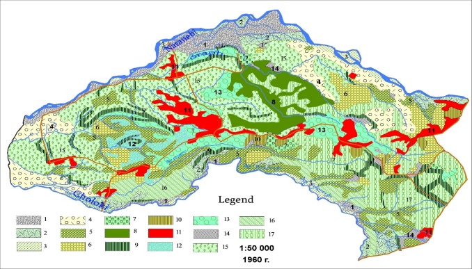
On the territory of the Laituri Soviet Tea Farm we distinguished the landscapes as landscape forms in the map of landscapes – Figure 8, Table 3 (in their authentic form till the 90-s of the last century, according to the topographic map published in 1960). Regarding agricultural use of the territory mainly tea plantations and citrus gardens are presented (see the Landscape Map of the Soviet Tea Farm of Borough Laituri). Just small areas are covered with tung trees, windbreak zones containing mainly Japanese cryptomeria and cedar.
Fig. 8. Landscape map of the Laituri Soviet Tea Farm
Before establishing the Soviet Tea Farm (1930) the territory of Laituri was covered with dense impenetrable forests of alder, Imeretian oak, Hartvisian oak, lime, beech, hornbeam, chestnut and etc. The brushwood consisted of Pontic rhododendron, holly, butcher’s broom, bilberry, blackberry, azalea and etc. Among lianas the Colchian ivy, amilax and others were found. Nowadays those forests do not any longer exist and they have been replaced with agricultural landscapes. The most of the animal species have died out. From the 20-s of the last century agricultural species were intensively being cultivated. Nowadays the hills here are occupied by tea-plants, citrus, windbreak zones, tung trees, roads, residential and other kinds of buildings.
Table 3. Landscape of the Laituri Soviet Tea Farm (1960)
N | Llandscape | Area km2 | % |
1 | Flood plain with alluvial soil, basically with alders, lions and bushes. | 2.86 | 5.51 |
2 | Riverine meadows, with alluvial soil (use basically for pastures). | 2.19 | 4.2 |
3 | River Islands. | 0.91 | 1.75 |
4 | At riverine bushes, with alluvial soil. | 1.43 | 2.75 |
5 | Forest groves (basically with alder and with hornbeam). | 5.65 | 10.90 |
6 | The hills with red soil and with citrus plantations. | 3.96 | 5.70 |
7 | Plain and terraced slopes with hazelnut plantings. | 1.12 | 2.11 |
8 | Strong inclined slopes with the forest (alder, hornbeam,maple, cedars). | 2.62 | 5.05 |
9 | Wind-proof strip basically with Japanese сryptomeria and with cedars. | 5.65 | 10.90 |
| 10 | Slightly wavy plain, with yellow soil and with vineyards. | 0.57 | 1.09 |
| 11 | Residential landscape | 3.24 | 6.24 |
| 12 | Marsh place with humid meadow vegetation. | 0.97 | 1.87 |
| 13 | Medium inclined slopes, with tung seedlings. | 4.09 | 7.88 |
| 14 | Marsh fragments. | 0.76 | 1.46 |
| 15 | Hill and knoll with rad soil and with tea plantations. | 9.25 | 17.83 |
| 16 | Slightly inclined slopes, In some places swamped, podzolic radsoil and with tea plantations. | 2.47 | 4.76 |
| 17 | Hill and low mountains slopes with rad soil and with tea plantations. | 6.5 | 12.5 |
| Total | 52.85 | 100 |
The relief consists of small flattened areas, low terraces, hills, low hills, at some places segmented by erosive ravines and gorges. Due to low absolute height, slanting slopes, flat areas and low rate of fragmentation the relief is mostly fit for agriculture. The average declination of the slopes is 10-150, extremely declined areas -25-350 alternate with slanting 18-200 slopes. In the west it is bounded by the Natanebi-Choloki coastline accumulative lowland valley and in the east – by the Ekadia-Anaseuli Hill. The geologic structure is mostly presented with Quaternary Upper Pleistocene and modern alluvial sediments. The lithology is made of Quaternary sandstone, clay, conglomerates, marine and continental molasses. At some places (extremely steep slopes) the clayey layers have been washed off as a result of erosive-denudative processes. Thick clayey layers are mostly met on comparatively slightly declined surfaces. The modern sediments are presented as sandy-clayey and deluvial-proluvial sediments, also laterite, on the eroded crust of which red earth is observed.
Development of the landscapes on the territory of borough Laituri can be described as the following stages:
Stage I – after clearance of the natural vegetation cover (forest landscapes) the agricultural landscapes (mainly tea plantations, also citrus gardens, tung trees and etc.) were formed;
Stage II – destroyed, uncultivated landscapes (agricultural), degraded tea plantations (covered with ferns, thorny undergrowth, at some places – arboreal plants);
Stage III – agricultural landscapes (plantations of nut, bog whortleberry) developed at the places of the grubbed tea plantations (degraded).
Fig 9. Landscape map on the territory of borough Laituri (2017)
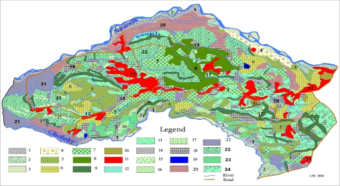
Table 4. Landscape on the territory borough Laituri (2017)
N | Landscapes | Area km2 | % |
| 1 | Flood plain with alluvial soil, agricultural crops (corn, vegetables). | 1.74 | 3.29 |
| 2 | Riverine meadows, with alluvial soil (use basically for pastures). | 1,29 | 2.12 |
| 3 | River Islands. | 0.93 | 1.74 |
| 4 | At riverine bushes, with alluvial soil. | 0.63 | 0.01 |
| 5 | Forest groves (basically with alder and with hornbeam). | 5.36 | 10.14 |
| 6 | The hills with red soil and with citrus plantations. | 2.70 | 5.10 |
| 7 | Plain and terraced slopes with hazelnut plantings. | 3.76 | 7.11 |
| 8 | Strong inclined slopes with the forest (alder, hornbeam, maple, cedars). | 1.85 | 3.50 |
| 9 | Wind-proof strip basically with Japanese сryptomeria and with cedars. | 2.82 | 5.33 |
| 10 | Slightly wavy plain, with yellow soil and with vineyards. | 0.57 | 1.07 |
| 11 | Residential landscape | 3.85 | 7.28 |
| 12 | Marsh place with humid meadow vegetation. | 0.12 | 0.2 |
| 13 | Medium inclined slopes, with tung seedlings. | 1.83 | 3.46 |
| 14 | Marsh fragments. | 0.79 | 1.49 |
| 15 | Hill and knoll with rad soil and with tea plantations. | 0.48 | 0.9 |
| 16 | Slightly inclined slopes, In some places swamped, podzolic radsoil and with tea plantations. | 0.41 | 0.77 |
| 17 | Hill and low mountains slopes with rad soil and with tea plantations. | 0.70 | 1.32 |
| 18 | Chopped down tea plantations. | 3.28 | 6.20 |
19 | Ponds | 0.08 | 0.15 |
| 20 | Arable land (Flood plain) Cereal crops and Vegetables crops. | 3.72 | 7.03 |
| 21 | whortleberry. | 3.03 | 5.73 |
| 22 | Hill and low mountains slopes with rad soil and with degraded tea plantations. | 6.19 | 11.71 |
| 23 | Slightly inclined slopes, In some places swamped, podzolic radsoil and with degraded tea plantations. | 1.87 | 3.53 |
| 24 | Hill and low mountains slopes with rad soil and with degraded tea plantations. | 3.97 | 7.51 |
| Total | 52.85 | 100 |
Thus, the landscape development took place in different conditions. We constructed a landscape map of the Laituri Soviet Tea Farm (1960) by GIS software and a landscape map (scale 1:50 000) depicting the current state (2017) of the territory. The maps were constructed by use of a topographic map (scale: 1:50 000) published in 1960, Google space images made in 2015, also the data of field-expedition observations (2010-2017).
Among agricultural species tea plantations occupied the most part of the areas (18%); comparatively less area was covered with citrus species (6%) and tung trees (7%). The study analyses show that the basic part – 66% of the tea plantations are barren and degraded; only 10% of it has been chopped down. As far as grubbing requires much expenses the tea plantations in most cases are derelict and covered with fern and thorny undergrowth. Only 24% of the tea plantations have more or less survived and just a minor part of them produces yield nowadays. Some part has been cleared and replaced with nut, persimmon and bog whortleberry.
According to the data of the topographic map of 1960 the grove of the river Natanebi located to the north of the Farm is unused and the landscapes are mainly presented as fluvial meadow-shrubbery and the material cast out by the river. As mentioned above, clearance of degraded plantations is quite costly. Therefore, unused lands were cultivated, namely, the large area of the Natanebi grove, which was generally unused in the past (according to the data of 1960 topographic map) nowadays is almost completely covered with agricultural species (maize, vegetable and garden cultivars) (Fig.10, Fig.11). During the half-century period the area of the residential landscape has increased by 0.3%.
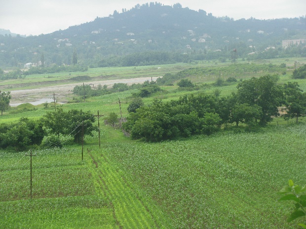
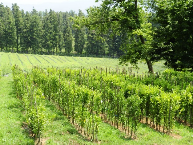
Fig 10., Fig 11. Agricultural landscapes of borough Laituri (maize, vegetable, garden cultivars and bog whortleberry plan)
Thus, on the study territory as well as generally in the humid subtropical landscapes, namely, in the region of the tea agrolandscapes, the main parts of the areas have undergone certain changes due to social-economic factors, namely, certain agricultural species have been replaced with cultivars, which are more profitable on the market nowadays.
The authors declare that they have no conflict of interest
No funding sources
The study was approved by the TSU Vakhushti Bagrationi Institute of Geography.
Georgian Scientific-Applied Climatic Reference, Part I, Specific Climatic Characteristics. 2004, Tbilisi, pp. 10-20. (In Georgian).
Karkashadze, N. Tea Economy in the USSR and Prospects for Its Development. Tbilisi, Georgia, 1982, pp. 29-35. (In Georgian).
Aplakov, P. "Prospects for the Development of Tea Growing in Georgia." Journal of Social Economy, vol. 48, no. 4, 2006, pp. 131-141. (In Georgian).
Zonenashvili, J. Agriculture, the Territorial and Specialized Structure, Geography of Georgia, Part II. Tbilisi, Publishing House: Media Servisi, 2003, pp. 126-127. (In Georgian).
Kvaratskhelia, T. Tea Bush and Accompanying Crops. Moscow, 1934, pp. 38-40. (In Russian).
Meladze, G., and M. Meladze. Agro-Climatic Resources of Western Regions of Georgia. Tbilisi, 2012, pp. 382-395. (In Georgian).
Gagua, G. Agroclimatic Zonality, Map (1:1,500,000). National Atlas of Georgia, Franz Steiner Verlag, Stuttgart, 2018, p. 57.